Posts

Showing posts with the label hiking trail

Hiking Theodore Roosevelt National Park
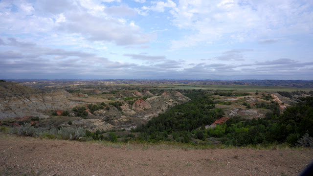
Image
  Where is Theodore Roosevelt National Park? Theodore Roosevelt National Park is located in western North Dakota. The drive from Bismarck is approximately two hours. This large park has three sections, linked by the Little Missouri River. Painted Canyon is about 15 minutes East of the South Unit, off of Interstate 94. The North Unit and South Unit are separated by approximately 70 miles. Why visit Theodore Roosevelt National Park? The park offers access to the beautiful North Dakota badlands and the Little Missouri River. It is named in honor of the influence the area had on Theodore Roosevelt, who hunted and ranched in the Little Missouri badlands as a young man. What should one expect on the trails at Theodore Roosevelt National Park? The trails in the park are rugged. In places, they are steep and rocky, and they are not always well-marked. Be prepared for rapid changes in weather conditions, and be aware that the trails can become very slick after rainfall. Many of the trails ...

Hiking After Work in Tucson, Arizona: Tucson Mountain Park [Sarasota Trailhead Loop]

Image
 Where is Tucson Mountain Park? Tucson Mountain Park's Sarasota Trailhead is located approximately 20 minutes southwest of downtown Tucson, Arizona. Why visit Tucson Mountain Park? Tucson Mountain Park features over 62 miles of non-motorized shared use trails for hikers, equestrians, and mountain bikers. At approximately 20,000 acres, it is one of the largest natural resource areas owned and managed by a local government in the United States! In addition to the trails, there are opportunities for picnicking and camping. There are many breathtaking views, including the Gates Pass Overlook, and the sunsets are sensational.  What should one expect on the trails at Tucson Mountain Park? The trails at Tucson Mountain Park are wide and well-marked. There is ample signage to direct you, and maps are often provided at trail junctions. It is possible to create a variety of routes from the many trails available. One example would be a 5-mile loop around Bobcat Ridge, utilizing the Sara...

Hiking After Work in Tucson, Arizona - [Brown Mountain Trail]

Image
  Where is Brown Mountain located? Brown Mountain is located about 30 minutes west of downtown Tucson, Arizona. Brown Mountain and Brown Mountain Picnic Area, where the trailhead is located, are within Tucson Mountain Park. The trailhead is just south of Kinney Road, on McCain Loop Road. What should one expect when hiking Brown Mountain? The hike is approximately 4.8 miles round-trip. The trails are mostly rock and gravel, with some loose rock present. We would definitely recommend wearing appropriate hiking footwear when hiking at Brown Mountain. The trail is, however, well-marked and well-maintained. While the altitude is not breathtaking, at a maximum of 3,098 feet, it is high enough to provide great views of the surrounding area. There are plenty of views throughout the trail, as there are dual peaks, and a section of the trail is an exposed ridgeline. The views only require a modest effort, as there is only about 400 feet of elevation gain on the trail.  Tucson Mountain ...

Hiking After Work in Tucson, AZ [Starr Pass Trailhead]

Image
I headed over the Starr Pass Trailhead late in the afternoon, after completing the nearby Hidden Canyon Bowen Trail Loop. I wish I would have had more time to explore this area and will definitely look to do so on my next trip to the Tucson area!   Where is the Starr Pass Trailhead? The Richard E. Genser Starr Pass Trailhead is located southwest of Tucson, on the edge of Tucson Mountain Park, approximately 15 minutes from downtown. The trailhead can be found behind the Starr Pass Golf Resort.  What should you expect on the trail? You will start out on the Starr Pass Trail, which winds around Mine Mountain. You can grab some pretty spectacular views of the Tucson area at the top; however, it's a bit of a scramble, as there is quite a bit of loose rock to contend with. Be careful with your footing, and move more slowly than normal, if necessary. The trail intersects with the Rock Wren Trail, which heads into Tucson Mountain Park and meets up with the Yetman Trail. Alternatively...

Hiking After Work in Tucson, AZ [Hidden Canyon Bowen Trail Loop]

Image
I set out, in the middle of the afternoon, towards the Hidden Canyon Bowen Trail Loop. I was able to fit this loop trail, as well as another short hike from a nearby trailhead, in before dark.   Where is the Hidden Canyon Bowen Trail Loop? The trail is on the southwest side of Tucson, on the edge of Tucson Mountain Park. The trailhead may be a little tricky to find the first time you visit. It's located behind the JW Marriott Starr Pass property, and I had to travel through most of the resort to get there. I parked on the side of the road, next to the trailhead, and did not experience any issues. What should you expect on the trail? The trail is a relatively short two-mile loop. I only saw a couple of other hikers out on the trail when I visited in February. There isn't much elevation gain, which makes it suitable for most hikers. I would suggest choosing stable footwear, however, as there are some loose rocks and stones along the trail. I would also advise bringing enough wat...

Letchworth State Park (NY) - Finger Lakes Trail

Image
The Letchworth branch of the Finger Lakes Trail is a point to point trail, easily accessible from a variety of locations. At 22 miles, it is possible to tackle in one day, but two shelters along the trail also allow for a moderately-paced two day trip or relaxed three day trip.  The trail follows yellow blazes along gently rolling terrain, with short, steeper inclines cutting switchbacks across narrow ravines.      This trail offers year-round attractions, from mountain biking to cross country skiing, and while summer shows off the lush foliage common to western New York's hardwood forests, our fall trip afforded comfortable temperatures and unrestricted views of the gorge.  Starting at the southern end on day one, we were able to capture some of the beauty of the falls. Our footfalls were crisp across the dry leaves, indulging a consistent serenity to our progress. We built a fire and felt its warmth as we listened to coyotes howl and watched por...

White Mountains - Day 4 [Franconia Brook Trail]

Image
Despite the rain and strong winds overnight, we had slept soundly and for many hours. As we ate breakfast, we thought about the first foods we would eat once we emerged from the forest. When we began our final day of hiking, only about eight miles separated us from our original starting point.    The brooks, which we would have to cross a few times over the course of the day, were swollen from the previous day's rain. We marveled at the sheer power of the water crashing over the rocks as we left the campsite. Further down the trail, we passed through an area that was somewhat flooded out, due to the combination of precipitation and beaver activity.      While much of the second half of the trip was wet, the sun reappeared to lift our spirits as we hiked towards the finish. As we neared the Lincoln Woods Trail, we began to encounter other hikers more frequently. As we officially exited the Pemigewasset Wilderness, we stopped to chat with a group who had spent the...

White Mountains - Day 3 [Ridin' the Storm Out]

Image
  We began Day 3 with a visit to Garfield Pond. The setting was serene, but knowing that the weather was supposed to turn, we decided not to linger too long. We got an early start on the relatively short hike, along the Garfield Ridge Trail, to the summit of Mount Garfield. We were glad we did, as we were rewarded with clear views from the summit.              After we left the summit of Garfield, the weather began to deteriorate rather quickly. The temperature was in the low to mid 40s. The wind picked up significantly, and by about 10:00AM, a steady rain had begun to fall. The steady rain would remain with us throughout the day and through much of the night, with occasional stronger downpours.  When we approached Galehead Mountain, we were faced with a difficult decision. The Twin Brook Trail would be our final opportunity to descend from the loop before another exposed ridge. Tom made a quick run down the side (Frost) trail to the summit a...

White Mountains - Day 2 [Franconia Ridge]

Image
  After some oatmeal and coffee, we headed back up to rejoin the Franconia Ridge Trail. Little Haystack was our first peak of the day. The number of people milling about on the summit was a bit surprising, given the timing and conditions; however, there is another popular trail that leads to the peak. Temperatures were in the 40s, with a stiff breeze, and we were, unfortunately, surrounded by thick clouds. There would be few of the spectacular views, of the valley below, we had enjoyed the previous day.   The clouds would remain for the entirety of the 1.7 miles to the summit of Mount Lafayette. Although we missed out on the views of the landscape that extended below us, we were fascinated by the alpine vegetation. At times, it felt as though we were on another planet. Our stay atop Mount Lincoln, in between Little Haystack and Lafayette, was extremely brief, as the increasingly strong winds made for a brisk passage of the exposed ridge line. I felt the elevation change m...

White Mountains - Day 1 [Mount Flume & Mount Liberty]

Image
We began our hike at the Lincoln Woods Visitor Center, located on Kancamagus Hwy (Route 112), in Lincoln, NH. Though there were signs that the just-concluded weekend had brought droves of fall foliage appreciators, the advantages of starting the trip on a Monday included ease of access to parking. We remitted our $5/day parking fee at the self pay station and were soon on our way.   The journey started off in an unassuming fashion. We were in high spirits and enjoyed absolutely perfect weather as we hiked along the Pemigewasset River. It wasn't long (only about 1.4 miles) before we reached a junction for the Osseo Trail. The day's work was about to begin, as the flat terrain quickly became upward slopes and the relatively smooth footpaths began to gradually give way to the uneven, rocky traverses that would define our next couple of days.   The slopes on the Osseo Trail (4.1 miles) continued to steepen until, ultimately, we were presented with a series of ladders that represen...