Great Smoky Mountains National Park - Day 1 [Clingmans Dome, Appalachian Trail, Silers Bald, Welch Ridge Trail, Hazel Creek Trail]
We awoke early (around 5:00AM) on a Thursday morning to make the drive from our AirBNB, in Knoxville, to Clingmans Dome, where we would begin our adventure. After a stop, a detour, and some road construction in the park, we arrived to the parking lot for Clingmans Dome just before 8:00AM. If you want to enjoy the views without too much interruption, we highly recommend getting to the parking area in the early morning hours. The contrast between the relative serenity of starting our hike in the early morning and the bustling scene we returned to, several days later, in the middle of the afternoon, was a bit surreal. Arriving early also allowed us our choice of parking, and we chose a prime spot, within view of the Clingmans Dome Information Center. If the road construction is still in ongoing when you read this, definitely allow for extra time when traveling outside of the early morning and late afternoon hours.

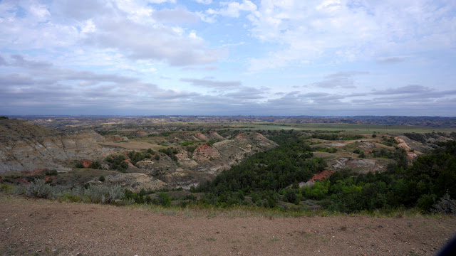
A few voices droned and an occasional car door slammed shut as we pulled out our gear and took a few shots of the Smoky horizon. The scene was picturesque. A warm blanket of low clouds shrouded the valley. Blue mountains erupted towards the crisp frozen sky. The morning sun slowly breached the boughs of fir and gently washed the frost-covered dandelions. The lot had begun to fill around us in the ten or so minutes it took us to compose ourselves. The cadence of the car doors hastened, and it was time for us to begin our trek.
At 6,644ft, and the highest point on the Appalachian Trail, the accessibility of Clingmans Dome is noteworthy. The climb can be made almost entirely by car. Ample handicap parking stalls and a half mile of well-maintained asphalt make the remainder of the ascent accessible to many visitors. Upon reaching the summit of the wooded dome, the peak's iconic ramp-style observation tower rises an additional 45ft into the pristine mountain air. It crests over the surrounding canopy and offers compelling 365-degree views.


More adventurous day hikers may also seek out views from Andrews Bald, which can be reached via an unpaved 3.5 mile out-and-back trail, featuring stairs
and walkways in many of the more challenging areas. This accessibility
effort also reduces erosion on the heavily-traveled trail. Pets are not allowed on most trails in Great Smoky Mountains National Park, but the National Park Service does outline some options for hiking with your dog here: Visiting With Pets.
On our first day we hiked a little over 4 miles of the Appalachian trail, from Clingmans dome to Silers Bald. It’s a well-worn ridgeline path traversing the Tennessee/North Carolina border, and it continued to afford us intermittent views of the clouds stubbornly clinging to the mountains. Being early May, it also yielded a supply of thru-hikers eager to share whatever sage wisdom they had been contemplating over their countless silent miles. Likely due to the rain and cold which had immediately preceded our trip, most of the advice that morning reflected a lust for dry socks and gratitude for the arrival of more mild weather. We stopped at the Double Spring Gap shelter, to chat for a few moments with a particularly friendly thru-hiker, before moving on towards Silers Bald. Upon Silers Bald, we appreciated the last of our breathtaking views for the day and soaked in some of the wildflowers that would line our descent of Welch Ridge.


We left the AT and headed down the Welch Ridge Trail (1.7 miles) to the Hazel Creek Trail. While the trails in GSMNP generally aren't blazed, they are well-marked, with easily legible signs providing mileage to upcoming intersections. These signs shouldn’t be taken as a replacement for a map and compass -- a mistake made by two day hikers we had encountered earlier, on the AT. They had attempted a more scenic route to the Clingmans Dome observation tower: one that runs parallel to the paved path, meanders west, then doubles back towards the dome. The duo had missed this final turn and continued over two miles away from their intended destination. It happens to all of us, but having proper navigation tools reduces the frequency.
Welch Ridge contained much of the same flora we would encounter over the next 8 miles, as we descended the Hazel Creek Trail towards our campsite for the evening. Wildflowers and fiddleheads abounded, and stunted birches and viburnums rose into a dense hardwood rainforest. Meadow plants were steadily replaced by ferns and lush moss, as we reached a series of switchbacks and the Hazel Creek Cascade. The trail can be challenging through this stretch. Narrow paths on these switchbacks are rocky, rooted, and cross multiple small brooks and springs. The reward is the absolute stunning solitude: waterfalls, trilling woodpeckers, and dense rhododendron leaving you momentarily lost in time.

The majority of the descent occurs in this first mile, after which it opens to a mild trail resting in the tracks of the abandoned Ritter Lumber lines. These rails made the forest accessible for heavy logging in the late 19th and early 20th century, removing massive hickory and poplar and leaving behind a smooth trail with washed out creek crossings and the anomalous axle.

After completing around 14 miles for the day, we reached camp just before dark. While we typically thought of our campsite reservations in terms of the site numbers, the locals we encountered referred the campsites by name (this evening we would stay at #82 - Calhoun). As Mike prepared the evening's dinner -- three types of beef stew, from various producers -- Tom went to set up shelter near the creek. Here he met two fisherman, who were the first people we had encountered since leaving the Welch Ridge Trail.
We reconvened about 20 minutes later to enjoy our evening meal. After comparing our observations on the various stew recipes, which we will share in a separate blog post, we retired for the evening. Exhausted, we drifted to sleep listening to the muffled rush of Hazel Creek and the drops of dew falling onto the tent from the trees above.


Comments
Post a Comment