Posts

Hiking Theodore Roosevelt National Park

Image
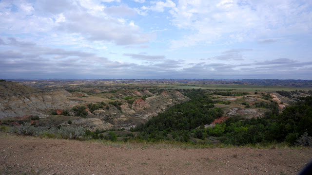
  Where is Theodore Roosevelt National Park? Theodore Roosevelt National Park is located in western North Dakota. The drive from Bismarck is approximately two hours. This large park has three sections, linked by the Little Missouri River. Painted Canyon is about 15 minutes East of the South Unit, off of Interstate 94. The North Unit and South Unit are separated by approximately 70 miles. Why visit Theodore Roosevelt National Park? The park offers access to the beautiful North Dakota badlands and the Little Missouri River. It is named in honor of the influence the area had on Theodore Roosevelt, who hunted and ranched in the Little Missouri badlands as a young man. What should one expect on the trails at Theodore Roosevelt National Park? The trails in the park are rugged. In places, they are steep and rocky, and they are not always well-marked. Be prepared for rapid changes in weather conditions, and be aware that the trails can become very slick after rainfall. Many of the trails are

Hiking in the Adirondack Mountains (NY) - Giant Mountain Wilderness [Giant Mountain & Rocky Peak Ridge]

Image
Where is the Giant Mountain Wilderness? The Giant Mountain Wilderness is located in Essex County, in northeastern New York. It is part of the Adirondack Forest Preserve and is adjacent to the High Peaks Wilderness. Why visit the Giant Mountain Wilderness? The 23,100-acre Giant Mountain Wilderness is home to two of the 46 Adirondack High Peaks -- Giant Mountain and Rocky Peak. Other notable natural features in the Giant Mountain Wilderness include Giant Washbowl, Giant's Nubble, Hopkins Mountain, and Roaring Brook Falls. What should one expect on the trails in the Giant Mountain Wilderness? The three main routes to the summit of Giant Mountain are the North Trail, the Roaring Brook Trail, and the Zander Scott/Ridge Trail. It is an additional 3-mile round trip between the summit of Giant Mountain and the high point on Rocky Peak Ridge. Alternatively, it is possible to summit Rocky Peak first, via the East Trail, or to take one of several trails to Hopkins Mountain, before joining th

Hiking After Work in Tucson, Arizona: Tucson Mountain Park [Sarasota Trailhead Loop]

Image
 Where is Tucson Mountain Park? Tucson Mountain Park's Sarasota Trailhead is located approximately 20 minutes southwest of downtown Tucson, Arizona. Why visit Tucson Mountain Park? Tucson Mountain Park features over 62 miles of non-motorized shared use trails for hikers, equestrians, and mountain bikers. At approximately 20,000 acres, it is one of the largest natural resource areas owned and managed by a local government in the United States! In addition to the trails, there are opportunities for picnicking and camping. There are many breathtaking views, including the Gates Pass Overlook, and the sunsets are sensational.  What should one expect on the trails at Tucson Mountain Park? The trails at Tucson Mountain Park are wide and well-marked. There is ample signage to direct you, and maps are often provided at trail junctions. It is possible to create a variety of routes from the many trails available. One example would be a 5-mile loop around Bobcat Ridge, utilizing the Sarasota

Hiking Lake Meredith National Recreation Area [TX] - Harbor Bay Trail

Image
Where is Lake Meredith National Recreation Area? Lake Meredith National Recreation is located in the Texas Panhandle, approximately 45 minutes from Amarillo. Why visit Lake Meredith National Recreation Area? The Canadian River has cut 200-foot canyons through this area, creating a haven for wildlife. Camping, hiking, fishing, hunting, and off-roading are popular activities in the recreation area. What should one expect on the trails at Lake Meredith National Recreation Area? There are a number of hiking trails available at Lake Meredith National Recreation Area. The Harbor Bay Trail is an out-and-back trail, featuring two optional loops. The entire trail is approximately 8 miles in length. A map of the trail can be found here. The Harbor Bay Trail features rolling hills, with views of Lake Meredith and Fritch Canyon. Exposed red clay and boulder fields are also highlights. Slopes can be rather steep, at times. Trail surfaces are primarily packed dirt, and the trail is generally wide,

Hiking Las Cruces: Aguirre Spring Recreation Area [Pine Tree National Recreation Trail] [Baylor Pass National Recreation Trail]

Image
  Where is Aguirre Spring Recreation Area? Aguirre Spring is located just East of Las Cruces, on the East side of the Organ Mountains. Why visit Aguirre Spring Recreation Area ? Aguirre Spring offers spectacular views of the Organ Mountains and Tularosa Basin. Trailheads for two National Recreation Trails reside within the recreation area. Inexpensive camping, with limited amenities, is also available. What should one expect on the trails at Aguirre Spring Recreation Area? Before setting out for the trails at Aguirre Spring, one should know that the last four miles of the access road are a winding and increasingly steep one-way loop. The road is paved and was in good condition when I visited, but please exercise caution and patience when arriving or departing the recreation area. Also, know that these trails are popular, so expect to encounter other hikers rather frequently. The Pine Tree National Recreation Trail is a 4-mile loop. Starting from approximately 5,500 feet above sea le

Hiking in the Adirondack Mountains (NY) - High Peaks Wilderness [Porter Mountain & Cascade Mountain]

Image
  Where is the High Peaks Wilderness? The High Peaks Wilderness is located in Franklin, Essex, and Hamilton Counties, in northern New York. Cascade Mountain and Porter Mountain are found in the northeastern portion of the High Peaks Wilderness. Why visit the High Peaks Wilderness? As the name would imply, the area is known for its mountainous terrain and is home to most of New York's highest summits. There are many scenic streams and waterfalls, in addition to the panoramic views. What should one expect on the trails in the High Peaks Wilderness? Porter and Cascade are considered two of the easiest of the 46 Adirondack High Peaks to summit. That doesn't mean they should be considered easy hikes. The hike to Porter Mountain, from the Highway 73 trailhead, is 2.8 miles and includes elevation gain of just under 2,000 feet. The trail branches off towards Porter Mountain just before the summit of Cascade Mountain, so it's relatively easy to make the quick side trip and bag both

Overnight Backpacking Loop in Virginia: Three Ridges Wilderness

Image
  Where is the Three Ridges Wilderness? The Three Ridges Wilderness is located in Virginia's George Washington National Forest, about 30 miles southwest of Charlottesville. There is parking at Reids Gap (at the intersection of the Blue Ridge Parkway and Virginia 664). It's also possible to start from the Appalachian Trail trailhead at Tye River. Why visit the Three Ridges Wilderness? The Appalachian Trail (AT) runs through the Three Ridges Wilderness, which is reason enough to visit. This loop features some spectacular views along the AT and a series of waterfalls and pools on the Mau-Har side of the loop.  What should one expect on the trails in the Three Ridges Wilderness? If you are not accustomed to hiking in the mountains, this will be a strenuous hike. If you are, this will probably be a moderate hike. The trails are rocky and uneven in many places, so be sure to wear proper footwear and watch where you place your feet. Much of the hike is spent ascending or descending